 PA
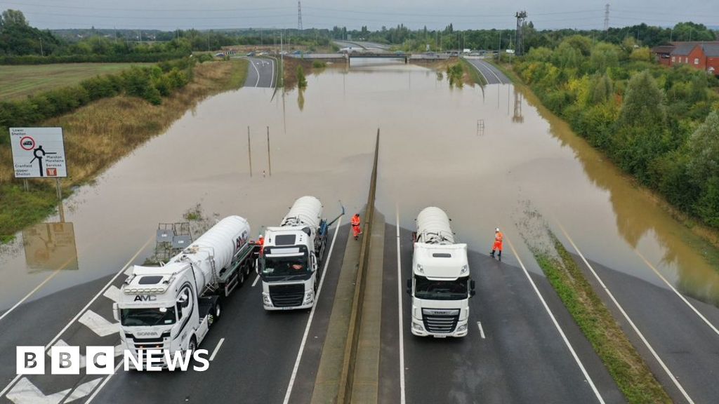
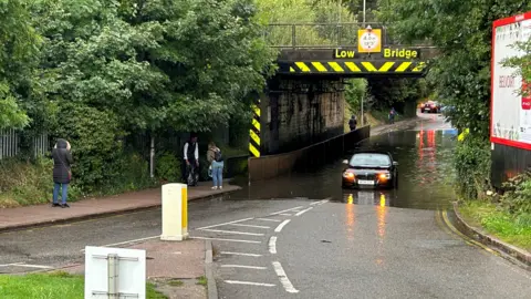
PAHeavy rain and flash flooding has hit parts of England as the Met Office warns further downpours are expected on Thursday night.
Drivers have been warned to take extra care travelling on roads that are holding flood water, particularly in parts of central of central and southern England, following days of heavy showers over the weekend and Monday.
Roads have been closed and rail services have been cancelled, while travel delays are expected into the weekend.
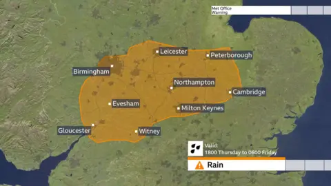
An amber warning is in place until 06:00 BST on Friday for some areas in the Midlands and central England with flooding and travel disruption expected, as a month’s worth of rain could fall.
On Thursday evening, the Environment Agency had 40 flood warnings and 114 less severe flood alerts in place across England.
Some areas covered by the amber warning could see 30-40mm of rainfall in three hours or less, and perhaps 50-60mm or more in around six hours, the Met Office says.
Places under the amber warning include Oxfordshire, Leicestershire, Bedfordshire, Gloucestershire, Cambridgeshire, Buckinghamshire and Worcestershire.
On Thursday, parts of Hitchin in Hertfordshire were struck by flooding, with Hertfordshire Constabulary confirming the closure of Cambridge Road in the town centre.
Areas of Solihull have also been hit, with West Midlands Railway warning of disruption and cancellations.
Tewkesbury Borough Council is handing out sandbags to residents to help protect their homes against flooding, advising them to stack them against their doorways.
North Northamptonshire Council has warned of “significant rainfall overnight” in areas where water levels are already high.
The council said it has been working with the fire service, police, Environment Agency and other local councils to protect residents from flooding overnight.
It also added that everyone evacuated from the flooded Billing Aquadrome holiday park on Tuesday night has been given temporary accommodation.
 PA Media
Matt Taylor, BBC lead weather presenter, said that some places within the amber warning area could see close to a month’s worth of rain overnight and, given how saturated the ground is following the rain already seen this week, existing flooding could be exacerbated further.
More travel disruption is likely and rivers will continue to rise after the rain clears.
The Environment Agency is reminding people to take care when driving through flood water.
Kate Marks, flood duty manager, said: “We urge people to plan their journeys carefully, follow the advice of local emergency services on the roads and not to drive through flood water – it is often deeper than it looks and just 30cm of flowing water is enough to float your car.”
National Highways network manager Stephen Basterfield said people expecting to travel by car should “adjust their driving behaviour and take extra care”, as heavy rain is expected to cause further flooding and disruption.
“Road users should plan their journey and check the latest updates on diversion routes before they travel as these could be impacted with more rainfall.”
Some areas covered by the warning have already experienced record September rainfall this month. Parts of Bedfordshire and Oxfordshire, in particular, have seen over three times their normal September rainfall.
 PA Media
Yellow rain warnings that remain in place elsewhere are:
- For northern England east of the Pennines and north-east England until Thursday midnight
- A separate warning southern England, southern Wales and parts of the Midlands until 09:00 on Friday
Less rain is forecast in areas under yellow warnings, but heavy downpours could still lead to flooding and transport disruption.
Rain is expected to clear later on Friday and the forecast is drier for the weekend, but forecasters say that a few showers cannot be ruled out, but not on the scale seen so far this week.
However, it will be colder for all and BBC Weather is monitoring the prospect of more wet, and also windy weather arriving later Sunday and into Monday.
Emergency services rescued 43 people from a holiday park in Northampton on Tuesday evening, after caravans were left surrounded by water from a nearby river which had burst its banks.
Areas including Buckinghamshire, Northamptonshire and Warwickshire were among the worst hit on Monday, the Met Office said previously.
Some places experienced more than a month’s worth of rain in a matter of hours over the weekend and Monday.
Football team AFC Wimbledon in south London said its pitch sustained “significant damage” after the nearby River Wandle broke its banks.
Note:- (Not all news on the site expresses the point of view of the site, but we transmit this news automatically and translate it through programmatic technology on the site and not from a human editor. The content is auto-generated from a syndicated feed.))
