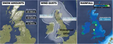
Storm Bert is forecast to hit the UK on Saturday, bringing high winds, potential flooding and some snow.
Disruption is expected over the weekend, with gusts of 40-60mph (65-96km/h) forecast in parts of Scotland, Northern Ireland, north Wales and northern England.
An amber warning for snow and ice has been issued for central Scotland, while numerous yellow warnings for rain and wind are in place for Saturday and Sunday.
The Environment Agency says heavy rain could lead to areas of localised flooding in northern England.
The turbulent forecast comes after an early cold snap brought snow and ice to many parts of the UK this week.
The Met Office has issued a number of weather warning for Saturday and Sunday:
- An amber warning for snow and ice for parts of of the Highlands, Aberdeenshire, Perth and Kinross and Angus from 07:00 until 17:00 on Saturday
- An amber warning for snow for parts of north-east and north-west England, and parts of the Scottish borders and south-west Scotland, from 07:00 until 12:00 on Saturday
- A yellow warning for rain and snow covering Northern Ireland from midnight until 11:00 on Saturday
- A yellow warning for rain for all of Wales from 06:00 on Saturday until 06:00 on Sunday
- A yellow warning of rain for the south-west of England and parts of the Midlands from 06:00 on Saturday until 23:45 on Sunday
- A yellow warning for rain and snow for most of northern England and Scotland from 04:00 on Saturday until 09:00 on Sunday
- A yellow warning for wind for much of the western coast of Scotland and north-west England, as well as north Wales and northern Ireland from 05:00 to 19:00 GMT on Saturday
- A yellow warning for wind for the eastern coast of Scotland and north-east England from 05:00 to 19:00 GMT on Saturday
- A yellow warning for wind for the south-west of England and south coast from 15:00 on Saturday until 21:00 on Sunday
The Irish weather service Met Eireann has issued a rare red warning for rain covering Cork and Galway on Saturday, warning of severe flooding and damage to homes and businesses.
Strengthening winds will be felt by all – but some of the strongest gusts, of up to 70mph (113km/h), will be around the Irish Sea and southern England coasts.
High winds will continue at times well into Sunday and Monday as Bert makes slow progress eastward across the UK.
Strong winds have the potential to cause damage and disruption to the transport network and buildings, with power cuts also possible.
Network Rail is already advising passengers to check journeys before they travel this weekend.
Avanti West Coast is advising customers not to travel north of Preston because of expected disruption.
Across south-west England and Wales, the Met Office expects between 50-75mm (2-3in) of rain could fall widely.
The heaviest and most persistent rain will fall in south Wales and south-west England, where there could be as much as 150mm (6in) – which would be the whole of November’s average rainfall in just a day.
As rain spreads across the country, there will temporarily be a bit of snow on the hills of Northern Ireland and Wales.
Bert is also expected to bring heavy snow and blizzards to higher ground in northern England and Scotland, making any travel very difficult.
The Met Office is forecasting as much as 20-40cm off snow on higher ground in an area north of Scotland’s central belt, where an amber alert for heavy snow and ice will be in force between 07:00 and 17:00 on Saturday.
Police are urging people not to travel on Scotland’s roads on Saturday as the country braces itself for more heavy snowfall.
 BBC Weather
Met Office spokesman Oli Claydon said Storm Bert was a “multi-hazard event” for the UK.
He added: “Because of the different nature of the weather across the UK, people really need to have an idea of what the forecast is for them specifically.
“Further south it’s wind and rain, further north it’s snow then rain and wind. So it really depends on where you are in the UK.”
An amber cold health alert is in place for much of England until 18:00 on Saturday.
It means there is an increased health risk to vulnerable people, and the UK Health Security Agency (UKHSA) has urged people to check on those who may be at risk.
Some people may be eligible for cold weather payments – a government benefit top-up to help with fuel bills during times of exceptionally cold weather.
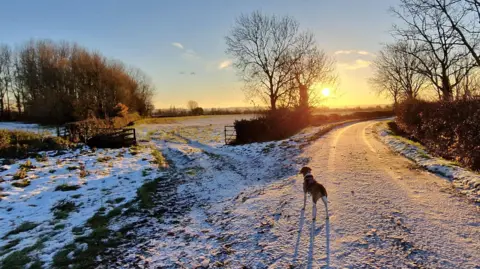
In Scotland, temperatures dropped to -6C (21.2F) on Friday morning. The country also saw one of the coldest nights of the year so far, with temperatures falling to -10C (14F) in parts of the highlands.
 BBC Weather Watchers/Helen Earth
But by Saturday, Wales, as well as central and southern England, could see temperatures of up to 12-15C.
It will remain cooler in the north, at 2-7C, before the milder weather spreads to all parts by Sunday.
A risk of ice remains on Friday, with parts of England and Wales set to see rain, sleet and a little snow. Northern and western Scotland will see more significant snow ahead of Bert’s arrival.
The cold weather has already caused disruption.
More than 100 schools across the Scottish Highlands and 30 in north Wales were closed on Thursday, while almost 200 schools in Devon and Cornwall shut or were partially closed due to the snow.
Note:- (Not all news on the site expresses the point of view of the site, but we transmit this news automatically and translate it through programmatic technology on the site and not from a human editor. The content is auto-generated from a syndicated feed.))


